Dr. Hal Needham has experienced a vast array of weather, having lived in Louisiana, Colorado, Alaska, the Middle East, and North Africa. It was during his time in Alaska, setting up weather stations and working with native communities, that his interest in science came to the forefront.
Known locally as “Hurricane Hal,” Galveston’s favorite weather guru studied hurricane science at Louisiana State University. He chose this specialty because of the high-impact nature of the weather phenomenon.
He moved to Galveston to further his knowledge of communities where weather is vital in everyday life.
“I like being where the impacts are affecting people,” Needham shares. “I enjoy the concept of communicating science to the public.”
Even here on the island, seemingly conflicting information from local sources can sometimes be confusing.
There are plaques just outside of Taquilo’s Tex-Mex Restaurant in downtown Galveston, that mark the high-water lines for several major hurricanes. Many people are surprised to see that the 1900 Storm mark is not the highest of the group.
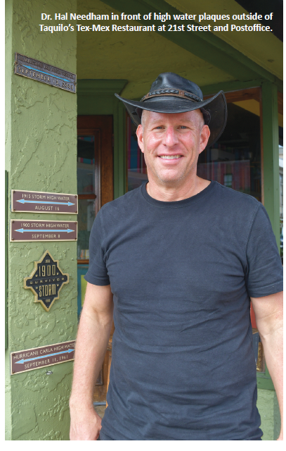 “On the island, the 1900 Storm did have the highest water level, which was 15.7 feet high. But a debris dam formed during the storm and surrounded the downtown area, almost like a horseshoe. It blocked debris and water from getting downtown,” Needham explains.
“If you look at our high-water marks at 21st and Postoffice streets, the 1900 Storm is number three, but island-wide it was the highest.”
Needham said that coastal floods from hurricanes, or saltwater floods, are the deadliest, most destructive natural hazards on the planet. While studying in Louisiana, he realized there was no reference database containing information about these storm surges.
“Where did they happen? When did they happen? How often did they happen? No one knew. It became my passion to go through scientific literature, academic literature, journals, anecdotal sources, and historic newspapers to find that information.”
“It was very time intensive. A storm like Hurricane Ike had 405 high-water marks from Texas to Alabama. I had a team of graduate and undergraduate students helping me with the data input,” he said.
He has continued to work on the compilation after he earned his doctorate and has now dubbed the database U-SURGE. It includes information about more than 750 hurricanes and tropical storms from around the world dating back to the 1800s.
“It’s a worldwide database, but we have more data for Galveston than any other city in the world, including high-water marks for 99 hurricanes and tropical storms.”
“We spent a lot of time over the past two years building the first elevation map for the majority of the buildings in Galveston, including about 80 percent coverage of the whole island,” Needham said.
“We’ve never seen this done for an entire city where we have elevations for about 18,000 Galveston buildings. We can take that and map out whole neighborhoods and project if a hurricane were to come in with a specific level of storm surge, what would be flooded and what would be dry.”
Though the entire data set is not publicly available online at this time, he is partnering with different private organizations to utilize the information. He is looking to collaborate with non-profits, the government, and others that can help make the data more accessible to the general public. He sees the data as something that would benefit insurance companies and weather forecasters as well as private citizens.
From his work with historical data, Needham surmises that FEMA flood estimations in many coastal communities are underestimated.
“In general, for most Gulf Coast communities, we believe [the estimates] are often two or three feet too low. Looking at the historical data we see three saltwater floods higher than nine feet.
“We believe what they say happens every 100 years, actually happens every 25 years. Knowing that history helps inform people because we're all trying to manage our money and resources.”
“When we think about insurance or assessing risk, we [refer to] FEMA flood maps that tell you if you're in the flood plain or not. We assume that they are based on history. They are not. They are based on hypothetical computer models that may be run in a completely different area,” Needham added.
“They might run these [models] in Florida or Washington D.C. and then hand you flood maps that say if you're in the floodplain or not. That’s not aligned with history.”
Needham states that when he compares storm history to FEMA maps in some areas they align well, but in others, they differ greatly.
“One of the biggest things that blindside people is the belief that if they’ve lived on a street for 30 years and it’s never flooded, they don’t need to carry flood insurance. You can go back and use research and see that if they had been there for 120 years, they would have seen flood water in their house two or three times.”
“It’s a very human mindset that thinks of 30 or 40 years as a long time. For Mother Nature, it's a blink of the eye. Going back to use historical data can give people an idea of what potentially could happen in their community.”
Needham is also involved in projected, address-based flooding. He hopes to work with historic neighborhoods and other smaller communities to complete this data.
“We just did a two-year project in Biloxi, Mississippi where we built out their flood history and also built out a map showing the elevations of all the buildings so we can super-impose on that.”
A unique feature of this scientific endeavor is Needham’s enthusiasm for community involvement in sharing pieces of history and experiences.
“We want the input of librarians, historians, scientists, the public, and someone who has a picture of their aunt's house in the 1961 flood. That's valuable to help build your flood history and to run our statistics.”
“I think people should get excited about this. Many cities have records about temperature and rainfall dating back over 100 years, but not about coastal flooding - even though that's the deadliest, most destructive natural hazard,” he said.
“These storms are rare and difficult to measure. You can have a tide gauge on the coast for 50 years measuring the water levels. But, when a hurricane pushes through, it destroys the gauge. So, the way that we measure scientific data through instruments, doesn't work in these huge storm surges because the gauges get destroyed.”
His distinctive approach of combining historical research and scientific study provides a promising addition to the way that populations might prepare for weather events.
“We can take a hurricane center forecast and turn that into an impact-based map and address actions based on flood forecasting. Knowing the risk and history of your community empowers you to make informed decisions.”
The immediate challenge Needham faces is figuring out how to make the information he has gathered available on a city or community level. Another consideration is how to make the database tool pay for itself.
“We're very open right now for dialogue, partnerships, and interactions. We want the data to be used. We need to figure out a way to [put this data in] the hands of the public so they can make important decisions.”
Needham shares his interest in weather through a walking tour about the impacts of hurricanes, technology, and the resiliency of Galveston in dealing with their aftermaths. He encourages guests to share their own weather stories as well. He feels that understanding the history of storms, through personal perspectives, is a unique way to learn about his field.
“In recent years, we've had a lot of school tours as well as summer camps for junior high and high school students that [are interested in] Texas history and science.”
“I think Galveston is a great laboratory for history and science and to understand how these things apply in the real world.”
Locals have come to depend on Needham’s weather updates on his Hurricane Hal Facebook page. His weather-related podcast can be found at geo-trek.com, and his Hurricane and Resiliency walking tours will resume in the fall. Details will be available at www.galvestonhurricanetour.com. The homepage for his database is www.u-surge.net.